Property Record
70 E Highway 70 St, Arlington, TN 38002
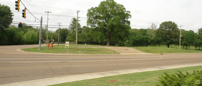
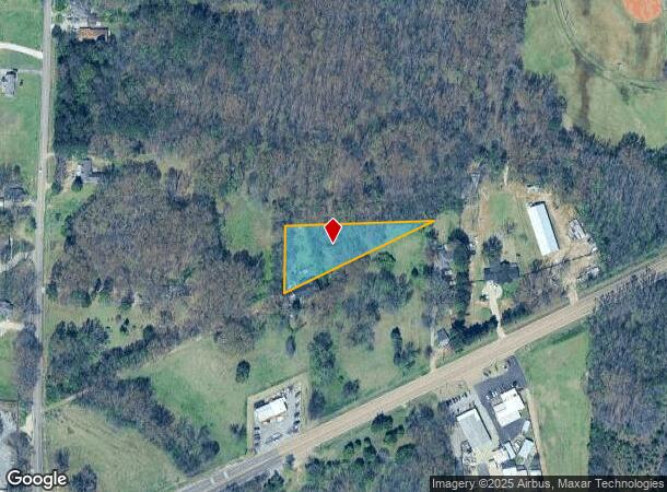
This Property Is For Sale
NEARBY LISTINGS FOR SALE OR LEASE
-
-
-
-
No Photo
-
-
-
-
View all Arlington listings for sale on LoopNet.com
Property Detail
70 E Highway 70 St
Memphis, TN-MS-AR
Anthony
B0-149-0-0644
743.18 FT E GERMANTOWN RD&445.02 FT N OF HIGHWAY 70
Vacantlandnec
Shelby
X
Tennessee
47157C0310G
pt2
2024
2.04 AC
2025
North
020836
Memphis
DEMOGRAPHICS near 70 E Highway 70 St
1 Mile
3 Mile
5 Mile
2024 Total Population
2,779
29,772
103,084
2029 Population
2,652
28,332
98,833
Pop Growth 2024-2029
(4.57%)
(4.84%)
(4.12%)
Average Age
41
41
39
2024 Total Households
914
10,628
38,217
HH Growth 2024-2029
(4.81%)
(5.02%)
(4.28%)
Median Household Inc
$104,018
$99,094
$80,870
Avg Household Size
2.80
2.70
2.60
2024 Avg HH Vehicles
2.00
2.00
2.00
Median Home Value
$276,557
$277,637
$247,195
Median Year Built
1988
1993
1992
Nearby Places
- Restaurants
- Banks
- Shops
- Fitness
- Groceries
PUBLIC TRANSPORTATION
AIRPORT
Memphis International
DRIVE
WALK
Distance
Memphis International
34 min
22.9 mi
Freight Ports
Port of Shreveport
DRIVE
WALK
Distance
Port of Shreveport
425 min
387.1 mi
Nearby Properties
Address
Land Use
TOTAL SIZE
Lot Size
Zoning
Address
Land Use
TOTAL SIZE
Lot Size
Zoning
1,153,892 SF
50.47 AC
I-P
Address
Land Use
TOTAL SIZE
Lot Size
Zoning
207,537 SF
21.73 AC
C-G
Address
Land Use
TOTAL SIZE
Lot Size
Zoning
591,149 SF
45.48 AC
CMU-3
Address
Land Use
TOTAL SIZE
Lot Size
Zoning
338,215 SF
33.08 AC
CA
Address
Land Use
TOTAL SIZE
Lot Size
Zoning
101,701 SF
39.63 AC
M-R
Address
Land Use
TOTAL SIZE
Lot Size
Zoning
498,680 SF
46.61 AC
I-P
Address
Land Use
TOTAL SIZE
Lot Size
Zoning
19,050 SF
24.99 AC
R-M
Address
Land Use
TOTAL SIZE
Lot Size
Zoning
62,852 SF
10.15 AC
RS-12
Address
Land Use
TOTAL SIZE
Lot Size
Zoning
222,468 SF
37.55 AC
C-H
Address
Land Use
TOTAL SIZE
Lot Size
Zoning
56,431 SF
1.24 AC
C-G
Address
Land Use
TOTAL SIZE
Lot Size
Zoning
199,320 SF
9.05 AC
CA
Address
Land Use
TOTAL SIZE
Lot Size
Zoning
134,599 SF
6.43 AC
I-P
Address
Land Use
TOTAL SIZE
Lot Size
Zoning
256,617 SF
10.54 AC
I-P
Address
Land Use
TOTAL SIZE
Lot Size
Zoning
86,875 SF
7.09 AC
I-P
Address
Land Use
TOTAL SIZE
Lot Size
Zoning
38,241 SF
3 AC
CMU-3
Address
Land Use
TOTAL SIZE
Lot Size
Zoning
211,953 SF
17.05 AC
C-H
Address
Land Use
TOTAL SIZE
Lot Size
Zoning
29,551 SF
1.89 AC
CMU-3
Address
Land Use
TOTAL SIZE
Lot Size
Zoning
76,169 SF
5.39 AC
I-P
Address
Land Use
TOTAL SIZE
Lot Size
Zoning
120,000 SF
9.64 AC
I-P
Address
Land Use
TOTAL SIZE
Lot Size
Zoning
269,880 SF
15.24 AC
I-P
Address
Land Use
TOTAL SIZE
Lot Size
Zoning
43,419 SF
5.73 AC
I-O
Address
Land Use
TOTAL SIZE
Lot Size
Zoning
69,158 SF
3.03 AC
CMU-3
Address
Land Use
TOTAL SIZE
Lot Size
Zoning
29,025 SF
3.47 AC
C-H
Address
Land Use
TOTAL SIZE
Lot Size
Zoning
53,517 SF
9.84 AC
C-H
Address
Land Use
TOTAL SIZE
Lot Size
Zoning
38,833 SF
4.84 AC
I-P
Address
Land Use
TOTAL SIZE
Lot Size
Zoning
50,486 SF
10 AC
C-H
Address
Land Use
TOTAL SIZE
Lot Size
Zoning
131,470 SF
18.30 AC
C-H
Address
Land Use
TOTAL SIZE
Lot Size
Zoning
232,375 SF
20 AC
I-P
Address
Land Use
TOTAL SIZE
Lot Size
Zoning
20,056 SF
20.76 AC
R-E
Address
Land Use
TOTAL SIZE
Lot Size
Zoning
72,009 SF
8.17 AC
C-H
The World's #1 Commercial Real Estate Marketplace
Connect with us
© 2025 CoStar Group
The information above has been obtained from sources believed reliable. While we do not doubt its accuracy we have not verified it and make no guarantee, warranty or representation about it. It is your responsibility to independently confirm its accuracy and completeness. Any projections, opinions, assumptions, or estimates used are for example only and do not represent the current or future performance of the property. The value of this transaction to you depends on tax and other factors which should be evaluated by your tax, financial, and legal advisors. You and your advisors should conduct a careful, independent investigation of the property to determine to your satisfaction the suitability of the property for your needs.